Flying site / Site de vol
Mentone, California, USA
Jérôme Daoust
( E-mail )
2025/1/20
-
Conditions
-
The club supporting the site / Le club supportant le site:
No info.
-
Events / Evénement:
No info.
-
Bulletin board / Tableau d'affichage:
No info.
-
Articles
-
Schools / Ecoles
-
Lost and Found / Object perdu ou retrouvé:
No info.
-
How to get there / Comment s'y rendre:
-
Start of dirt road up: Google Maps.
Gate near bottom is always open.
-
Maps / Cartes
-
GPS coordinates / Coordonnées GPS
-
Shuttles / Navettes
-
Site frequency / Fréquence du site: 144.925 MHz.
-
Insurance / Assurances
-
Lodging / Hébergement
-
Restaurant:
No info.
-
Car rental / Location d'auto:
No info.
-
Image
-
Video or Animation / Vidéo ou Animation
-
Cross Country / Vol Voyage
-
Hazards / Dangers
Conditions
Ideal is SSW wind, but this site is most often used when Marshall is not flyable:
Weather stations at launches (Crestline + Marshall Peak) and LZ.
Dusty Rhodes, 2017/3/26:
OK to launch when up to 40 mph North wind at Crestline.
It is best when flown at 3 pm or after (not noon), when wind gets organised from the valley.
If the winds are enough to ridge soar, do not launch it is rotor. You just want a 5 mph breeze.
By order of interest:
-
Forecast:
-
Windgram, for wind direction and altitude ceilings:
FlyMarshall.
Understanding "Wind Barbs".
-
RASP (Regional Atmospheric Soaring Predictor) for Southern California:
Soaring Predictor
(Older version).
Typical sequence:
-
Select day and time.
-
Select a parameter like "Sfc.Wind (10m)".
-
To change the opacity of the data layer:
Click the "+" or "-" icons in lower right
(Old version: Use slider in the upper right, or mouse's center wheel).
-
Finding flying sites:
Click the layer icon in the upper right, enable the "Sounding/SkewT".
Hover your mouse pointer over the markers, names appear.
Alternate website(s):
FlyMarshall.
-
Soaring Predictor: Detailed Predictions
(updated daily at 7:30 AM).
-
Typical optimistic altitude ceilings.
-
Mentone forecast (Weather Underground):
Hourly,
10 days.
-
Mentone forecast (Weather.com):
Hourly,
15 days.
-
Look for a fire nearby (associated air traffic):
-
Look for a TFR (Temporary Flight Restriction):
-
SkyVector.
-
SoaringData. Transforms local TFRs into a KML file for visualization in Google Earth:
-
Center airport identifier: sbd (San Bernardino International)
-
Bounding radius (stat. miles): 100
-
Airspace in Google Earth KML format
-
Append special use and ATC-controlled airspace uncheked
-
Type "Soar" into this box: Soar and press Submit
-
SoarCal / TFR. Click the map icon to visualize the TFR over a map.
-
FAA / TFR. Set "State" to "California", then click "GO" next to it.
-
Surface wind speed and direction - NOAA.
Definition:
Wind Barbs.
-
Forecast Discussion - San Diego area (NOAA).
-
Skew T plots.
-
Initial data source: Bak40 is most accurate, but limited to 24 hours.
GFS for longer range.
-
Start Valid Time: Latest.
-
Number of hours: 12 (up to 24 for Bak40).
-
Name(s) / Site(s):
SBD San Bernardino, ONT Ontario, RIV March AFB, BUO Beaumont, PSP Palm Springs,
VCV Adelanto Victorville, DAG Daggett Barstow, L94 Tehachapi, NXP 29 Palms,
WJF Lancaster, IYK Inyokern, BIH Bishop.
-
Choose "Interactive plot".
-
Windyty. Use bottom of screen to change forecast date/time.
-
Current:
Articles
Schools / Ecoles
for paragliding operating at this site.
Ordered alphabetically / Ordonné alphabétiquement:
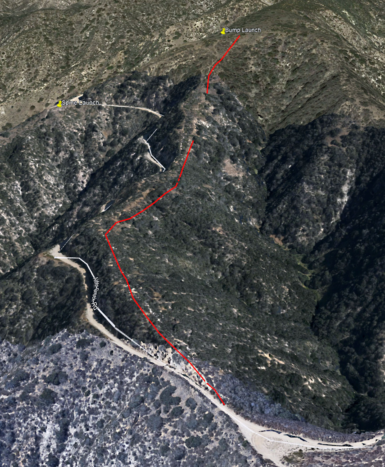
Maps / Cartes
GPS coordinates / Coordonnées GPS
| Description |
Latitude |
Longitude |
Altitude (ASL) |
| Santa Ana river dam LZ area |
N 34.1025° |
W 117.1073° |
570 m |
1869' (Approximate, from Google Earth) |
| Spine launch |
N 34.1188° |
W 117.1126° |
963 m |
3160' (Approximate, from Google Earth) |
| Bump launch |
N 34.1196° |
W 117.1106° |
1026 m |
3365' (Approximate, from Google Earth) |
For a great way to explore this flying site in 3D,
see Google Earth's Local points of interest in the
Maps section.
Shuttles / Navettes
-
If you see me (guy in orange flight suit) or my car (White Subaru Outback) ask me for a ride up.
-
Lua. 310-404-4750, call or text.
More info:
PG and HG.
Has a truck and a van available if needed.
Can also drive you and your car up to launch and have it at the LZ for your convenience.
-
Troy. 951-202-7037.
Will drive you up in your car, or his SUV.
Insurance / Assurances
-
You will need to become a USHPA member and it's not expensive
for the 1 month membership.
Just contact one of the
Schools
so you can take the one month membership for 10$.
It is good all over the US for the 30 day period.
-
Tu devras devenir un membre de l'USHPA et ce n'est pas cher
pour être membre pour un mois.
Tu as juste à contacter une des
Ecoles
afin de prendre le membersip d'un mois pour 10$.
Ce sera bon pour tous les sites aux Etats-Unis pour une
période de 30 jours.
Lodging / Hébergement
Image
Pictures/Images I took (click thumbnail to open full size image in a new window)
Photos/Images que j'ai prises (clique la petite image pour ouvrir la photo pleine grandeur dans une nouvelle fenêtre)
|
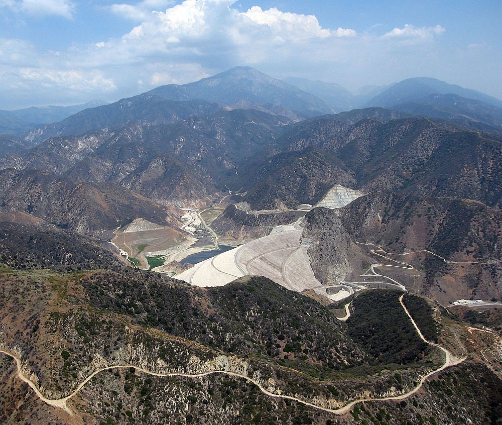
2006/7/8
|
Seven Oaks dam and Mentone Spine launch (lower left).
|
|
Le barrage de Seven Oaks et le décollage Spine de Mentone (en bas à gauche).
|
Pictures/Images from others (click thumbnail to open full size image in a new window)
Photos/Images des autres (clique la petite image pour ouvrir la photo pleine grandeur dans une nouvelle fenêtre)
|
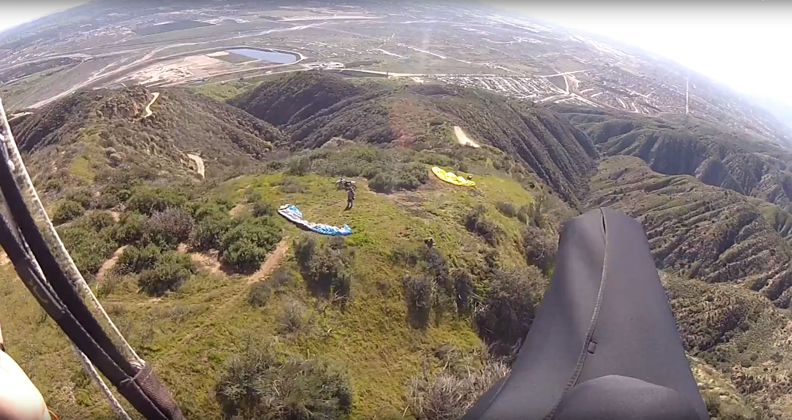
2017/3/8
|
Gavin flies over the Bump launch.
|
|
Gavin vole au-dessus du décollage Bump.
|
Personal pages:
Video or Animation / Vidéo ou Animation
Cross Country / Vol Voyage
Before you go, know your airspace. For Google Earth:
California 3D overlay for classes B/C/D and restricted military airspace.
Hazards / Dangers