Back to Thermal Lore : Article series.
Thermal Lore - Part 3
by Dennis Pagen (copyright © 2003), published in USHPA’s publication “Paragliding” February 2003.
All illustrations and figures are from USHPA.
My first thermal encounter was unwitting, as in, “What the hell is this?” The experience occurred at a dinky 450-foot former ski area in the spring of 1975. We flew that northwest slope nearly every weekend and I eventually opened a school there. I was flying a standard hang glider (four poles and a rag wing) that weighed only 35 pounds. We would hump the gliders up the hill and take as many sled rides as our youthful exuberance could stand. I had learned to ridge-soar the previous winter and knew that I needed a stiff breeze to stay up, given the typical 400 fpm sink rate of our gliders. So on that day it was sled rides in the 10-mph wind wafting straight in. It was my turn to launch and I edged to the edge. Just as I began my launch lunge, a major gust caught my wing and carried me and the whole ensemble upward. Naturally, I was going too slow and was turned. In a jiffy I was aiming back at the mountain, but lifted above the tops of the trees. Yikes!
I recovered from my surprise and completed the 360 to fly out to the front of the mountain. The lift was so strong, that by the time I cleared the ridge I was easily 100 feet above and climbing. Wanting no part of this robust air, I white-knuckled the bar and flew straight ahead to safety. The funny thing was, I kept climbing and climbing under a long roll of clouds. The farther I went, the higher I got. Eventually, I climbed to about 2,000 feet above the ridge and continued forward to land more than a mile upwind. By turns, I was surprised, then scared, then relieved, then full of bravado by the time my friends arrived to marvel at the flight. We were sure it was a record of some sort. Looking back, I realized that we all learned a lot from that experience, and someone even mentioned the possibility of something he had heard about called thermals. Now I know I was under a street, strung out for miles. In hindsight I also know that it was one of the best-looking X-C skies I have ever seen in these parts.
My first witting (as in intentional) thermal flight came in June of 1976. 1 was attending the first invitational meet at Grandfather Mountain in North Carolina. Several of us were soaring in light air on the northwest-facing cliff. The wind wasn’t strong, but plenty of buoyant lift was sliding up the mountain from the warm valley. Most of us were running back and forth along the half-mile ridge, but I noticed that two pilots, Steve Moyes and Rollie Davies, were flying out in front and turning a series of 360’s. By the time they were back near the mountain, they were hundreds of feet above us. The light bulb went off in my head. I realized exactly what they were doing, and the next time they went looking for a thermal, I followed. We didn’t have varios back then, but could feel the surge of lift and tell I was climbing by watching the mountain. I tried to match their circles and, miraculously, I was thermalling. I can’t describe the thrill of that moment. I repeated the experience for nearly an hour, but can honestly say that I learned to thermal in the first 15 minutes of realization and exploration and have been a devotee of augering upward ever since.
Sometimes it only takes forming the correct model in your head to let you catch on to a skill or concept. In fact, the main thing we are trying to do with this series of articles is to form a good working model of thermals in our image databank. The better images we hive to work with, the better we will perform when globular lift beckons. So, we continue with our exploration of the world of thermals where we left off last time.
INVERSION BEHAVIOR
Last month we investigated lapse rate and inversions, as well as their effect on thermals. We’ll begin here with a bit mire about inversions and then look at some details of thermal creation. The first question we should answer is, How are inversions formed?
As we learne4 in the previous installment, inversions are layers of air in which the air temperature does not decrease with increasing altitude, at least to the degree necessary for instabi1ity to occur. We also saw how this feature most readily occurs near the ground through the process of nighttime cooling. But we also encounter inversions aloft. At competitions, the air’s sounding (lapse rate graph) is often presented. It is not uncommon to see three inversion layers at different levels up to the altitude of common local cloud base. (Whether or not the clouds reach that altitude depends on whether or not the thermals can punch through the various inversions.) These inversions are very important for thermaling and cross-country prospects. They can gradually disappear or intensify.
Many inversions higher in the air come from the sliding of warmer air over cooler air that inhabits an area. This is the case when a warm front approaches. But even with a cold front, a layer of warmer air aloft is usually left as the cooler air plows under the warm. Cold fronts are typically limited in vertical extent, so on top they are capped by a warmer flow. If you look at charts or the wind flow near a front at different levels, you will see that aloft, the warm air is not being pushed out of the way by the cold air as much as it is at the surface.
Another cause of inversions is sea breezes moving inland. Usually these sea breezes act like mini cold fronts and move cooler air in under the existing warm air. Multiple sea breezes on succeeding days can cause inversions at different levels. Next we should mention the effect whereby mountains block lower flows and allow warm air moving into an area to pass over the mountain and thus above the cooler air on the other side. All of these causes may come into play in certain areas so that a complicated lapse-rate profile with multiple inversions of different strengths and thicknesses occurs. Below we’ll describe how thermals create inversions, which is perhaps the most important cause.
INVERSION CONVERSION
 There
are two factors that affect inversions. The first is the widespread vertical
movement of the air, and the second is thermals themselves. There’s a general
rule that you can bank on: The air rises in and around a low-pressure system,
and it sinks in and around a high-pressure system. In most of the U.S., the
passage of a cold front means the arrival of cooler, unstable air driven by a
high. Typically, one to three days of good thermal production follows the front
and then things get more stable as the high approaches. What’s happening here?
There
are two factors that affect inversions. The first is the widespread vertical
movement of the air, and the second is thermals themselves. There’s a general
rule that you can bank on: The air rises in and around a low-pressure system,
and it sinks in and around a high-pressure system. In most of the U.S., the
passage of a cold front means the arrival of cooler, unstable air driven by a
high. Typically, one to three days of good thermal production follows the front
and then things get more stable as the high approaches. What’s happening here?
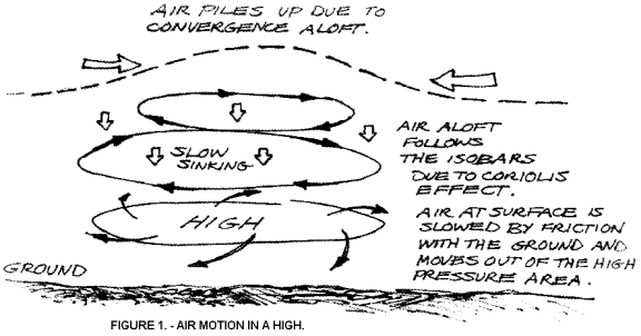
First we should note that although thermals may be rising vigorously in a high-pressure system, the general air mass is sinking at a rate of about an inch or two per minute. This sinking is caused by the air at the bottom of a high-pressure system flowing outward. This effect is shown in Figure 1. As a layer of air sinks, it becomes warmer due to compression caused by greater pressure. It also becomes more stable. When the opposite happens — a layer is lifted by some mechanical process, such as due to frontal movement or over a mountain — it becomes cooler and less stable. The cause of “mackerel sky,” with its array of alto-cumulus or cirro-cumulus clouds, is the result of thermals that are born high in the sky due to the lifting of a layer until it auto-convects.
 But
right now we are interested in highs (the weather kind, so we can achieve the
glider kind). The effect of the sinking air is to compress the layers of air
(as they move lower they have more weight above them), alter the lapse rate and
narrow the inversion layer while at the same time lowering it and essentially
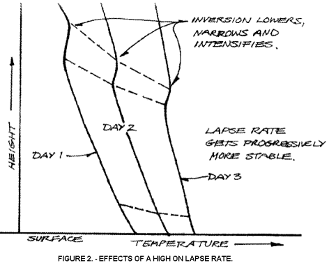
intensifying it. These effects are shown in Figure 2. Here we see the lapse
rate on three successive days. On the second day, the general lapse rate isn’t
as sloped as on the first. That means it has become more stable. Also, it is moved
to the right which indicates that the temperature is warmer at any given
altitude (this warming is exaggerated for clarity). We can clearly see that the
inversion has moved lower, and become narrower and intensified. This
intensification is the result of it having become more stable (slanted more to
the right).
But
right now we are interested in highs (the weather kind, so we can achieve the
glider kind). The effect of the sinking air is to compress the layers of air
(as they move lower they have more weight above them), alter the lapse rate and
narrow the inversion layer while at the same time lowering it and essentially
intensifying it. These effects are shown in Figure 2. Here we see the lapse
rate on three successive days. On the second day, the general lapse rate isn’t
as sloped as on the first. That means it has become more stable. Also, it is moved
to the right which indicates that the temperature is warmer at any given
altitude (this warming is exaggerated for clarity). We can clearly see that the
inversion has moved lower, and become narrower and intensified. This
intensification is the result of it having become more stable (slanted more to
the right).
Most of us know that high-pressure systems bring stable air and usually weak, nonexistent or punchy thermals. Now you see why. The mass is stable, and normal thermals simply die out in the stable air, or are stopped by the inversion layers that get lower and lower. Particularly strong heating at the ground may produce a thermal that rises for a good ways, but it will be quickly eroded, so only the strongest portions push upward and these portions will be well mixed (read turbulent). These high-pressure thermals should also seem familiar to coastal pilots, since they are very similar to thermals after a sea breeze has passed. The sea breeze is a thick layer of stable air moving inland from the sea. The reason this mass is stable is precisely for the same reason high-pressure masses are: the air has sunk from aloft to the surface (out to sea in this case). Sea breezes are beyond the scope of this series, so those who want to know more about this important facet of our flying should consult Understanding the Sky.
Readers with good memories may recall the story we told last month describing the day a hopeful flock of pilots expected the clear, crisp weather to deliver them a cornucopia of thermals. All they found was a bright, sunny, dreary day of dead air. This occurrence was precisely due to a big fat high squatting over the Eastern states. The air was cold and heated well from below, but since it was stable, thermals didn’t rise very high. It should be clear to us that lingering highs are a bane to good, wholesome thermal flying.
But there is some solace in high-pressure systems. The fact is, since they lower an inversion layer within the high, eventually the inversion reaches the ground and becomes part of the ground inversion, to be wiped out by the next day’s surface heating. In that way, a couple of days after a high-pressure system has hung over an area, conditions may suddenly get better again. Of course, we have described a weeklong process, considering the one- to three-day good soaring followed by stable air, then the return of good unstable conditions. The one thing we are all aware of is the variability of the weather, so the scenario we described is only a common possibility, not something on which you can rely. Often there is only one day of good soaring post cold front. Equally often, the inversions don’t have a chance to reach the ground because some other weather disturbances move through to start the cycles of warm front, cold front, warm front, etc., all over again.
THERMAL EFFECTS
As indicated above, thermals also have an effect on inversion layers as well as lapse rate. Think about the curriculum vitae, the résumé of a thermal. It is designed solely to wick heat away from the surface on a sunny day. Without thermals, heat would build up to an unbearable level (our northern climes would be like the steamy tropics, which themselves would be unbearable without thermals). So where does all this heat go? Up in smoke, of course. It gets transplanted to the air at various levels. Let’s start from the bottom up to get the picture.
 We
saw in the last installment of this series how the warming of the surface and
convective stirring eradicates a ground inversion, usually sometimes in the
morning. Then, when thermals trigger, the mixing begins higher and higher as
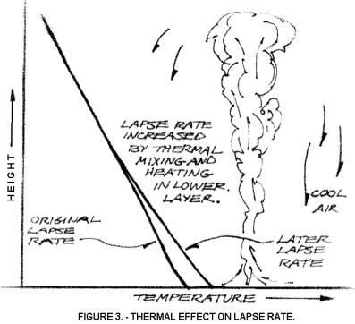
the thermal ceiling rises. So, thermals distribute heat upward, mix with the
surrounding air as they rise, and thereby alter the lapse rate. But we learned
last time that thermals are no longer warmer than their surroundings after they
rise to two-thirds or three-fourths of their maximum height. Thus, the heat
redistribution doesn’t go as high as the thermals. In Figure 3 we have illustrated
some of the principles described.
We
saw in the last installment of this series how the warming of the surface and
convective stirring eradicates a ground inversion, usually sometimes in the
morning. Then, when thermals trigger, the mixing begins higher and higher as
the thermal ceiling rises. So, thermals distribute heat upward, mix with the
surrounding air as they rise, and thereby alter the lapse rate. But we learned
last time that thermals are no longer warmer than their surroundings after they
rise to two-thirds or three-fourths of their maximum height. Thus, the heat
redistribution doesn’t go as high as the thermals. In Figure 3 we have illustrated
some of the principles described.
It should he clear that the lower few thousand feet above the surface will be warmed by the constant passage of thermals. The presence of downdrafts bringing cool air from aloft toward the surface spreads out the heating and mixes the air, so the change in the lapse rate is not as great as it would be if this mixing did not occur. But the net effect is to warm the lower atmosphere and actually make the lapse rate more unstable as shown. But the rub is, a thermal must be heated to a greater temperature in order to begin rising in this more unstable environment. So the thermals take longer to heat, become farther in between, but rise more vigorously once they do rise. This effect and the change in heating as the sun moves accounts for the difference in thermal strength and frequency as we go from morning abundance of weak thermals to afternoon increase in strength but decrease in frequency. The sudden evening cutoff of thermals occurs when the sun’s radiation no longer can raise the ground temperature above the trigger temperature. Residual heat may still release an occasional late thermal if something can trigger an initial rise. That something is usually cool air sliding down a slope in shadow or out of a canyon.
 When
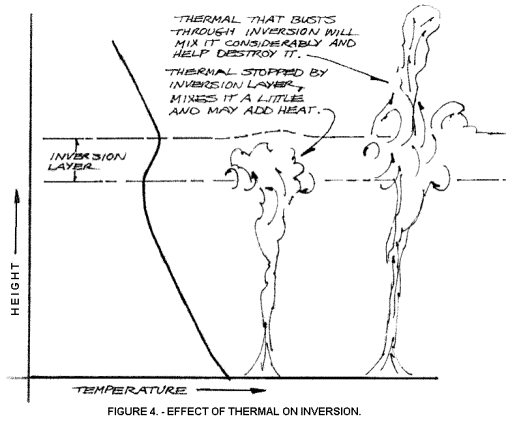
thermals enter an inversion layer they can intensify it, if it is sufficiently
low (so the thermals still have excess heat) and strong (so the thermals don’t
punch through it). On the other hand, thermals can wipe out or reduce the
strength of an inversion. To see how this happens, look at Figure 4. Here we
see some thermals strong enough to pass through the inversion, and some being
stopped in its clutches. The strong ones pass through, entrain air with them
and produce a general mixing that can thicken an inversion and thus make it
less intense. Even the thermals that are halted produce some mixing with the
layers of air above and below the inversion, so the inversion is rendered less
intense if the thermal isn’t warmer than its surroundings.
When
thermals enter an inversion layer they can intensify it, if it is sufficiently
low (so the thermals still have excess heat) and strong (so the thermals don’t
punch through it). On the other hand, thermals can wipe out or reduce the
strength of an inversion. To see how this happens, look at Figure 4. Here we
see some thermals strong enough to pass through the inversion, and some being
stopped in its clutches. The strong ones pass through, entrain air with them
and produce a general mixing that can thicken an inversion and thus make it
less intense. Even the thermals that are halted produce some mixing with the
layers of air above and below the inversion, so the inversion is rendered less
intense if the thermal isn’t warmer than its surroundings.
But the major effect that thermals have on inversions is to create them in the first place. Remember, we noted that thermals lose much of their excess heat as they rise and may simply erode away to nothing. However, often they reach the dew point or condensation level and form cloud. When cloud forms, the water vapor changing to water droplets releases a good deal of heat energy (called the latent heat of vaporization). This heat raises the temperature of the surrounding air as the cloud mixes with it vigorously. Now, this heat is not free money in the bank, but is only on loan, for as soon as the cloud starts evaporating, heat is again taken in the evaporation process and the surrounding air cools, then often sinks. That would be the end of the story, since the cooling would be as much as the initial heating, except for our good friend, the sun. Water vapor is greatly invisible to the sun’s rays, but water droplets are not. The sun heats the clouds itself and thus provides added heat energy to the area. So there is some residual heat left when the cloud evaporates. This heat builds up at the cloud formation level throughout the day and, voila, we have an inversion layer.
You can readily see that an inversion layer formed in this manner will persist through the night (there is nothing to cause an exchange of heat) and into the next day. If thermals don’t reach as high the next day (perhaps the mass has moved over more moist ground so cloud base is lower), a separate and lower inversion may be formed. In this manner, multiple inversion layers will be created.
No doubt inversion layers, like most things in the atmosphere, are more complex than we normally think, but they are extremely important to successful and excellent flying, so it behooves us to understand them as much as possible.
OUR WESTERN FRIENDS
We have been speaking of fronts, relatively low cloud bases and multiple inversions. The last two factors are often rare in the high desert area of the U.S. West, so let’s see what modifications are needed for our model to apply. To be sure, near the West Coast, you can encounter inversion layers accompanying the sea breeze, producing the famous LA smog which contributes to road rage and the genetic defects that result in Valley Girls. But further inland the inversions occur mainly when mountains trap cool evening air in a layer so thick that the day’s heating cannot produce thermals strong enough to bust through. This effect happens most often in the winter with weaker sunshine. Picture Salt Lake City for a model of this behavior.
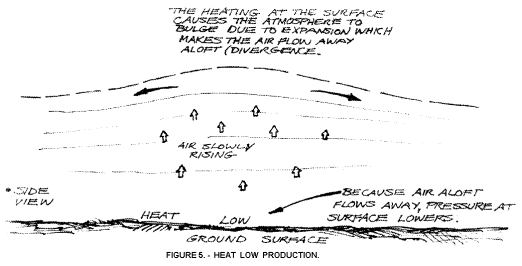 For
the most part, Western conditions create what is known as a heat low. This
process is very similar to that which takes place in the sea breeze. A local
area gets heated. The air expands and flows away high aloft due to the “bulge”
effect (see Figure 5). Once air flows away aloft, the pressure at the surface
is reduced (thus the term “heat low”) and a lower-level inflow occurs. The
process continues as long as the. heating continues. There is a net effect of
slowly-rising air over a widespread area. This slow rising would be an anathema
to flying in the moist East, since cloud would soon form and block the sun.
However, in the thirsty West, the rising air produces little cloud and thermals
are greatly enhanced.
For
the most part, Western conditions create what is known as a heat low. This
process is very similar to that which takes place in the sea breeze. A local
area gets heated. The air expands and flows away high aloft due to the “bulge”
effect (see Figure 5). Once air flows away aloft, the pressure at the surface
is reduced (thus the term “heat low”) and a lower-level inflow occurs. The
process continues as long as the. heating continues. There is a net effect of
slowly-rising air over a widespread area. This slow rising would be an anathema
to flying in the moist East, since cloud would soon form and block the sun.
However, in the thirsty West, the rising air produces little cloud and thermals
are greatly enhanced.
The general rising air, in combination with the dryness of the air (more solar heat), and the often bare ground is what accounts for the vigorous (and sometimes violent) thermals compared to their Eastern kin. There are few inversions formed in the high desert because the thermals don’t often reach a dew-point level, and if they do, the gradual rise of the air mass weakens them or puts them out of the reach of the next day’s thermals. Note that heat lows can be as small as a single field, or multi-state in expanse. In the summer, a heat low typically sets up that covers the entire front range of the Rockies, for example.
WHAT YOU CAN USE
Perhaps the main idea to take away from this installment is that inversions are a common enough occurrence that we should understand their cause and effect. If you only fly in the Owens Valley in the middle of summer, then perhaps you can ignore inversions, but the rest of us need to study them so we can avoid their worst disappointments. By learning how inversions change from day to day, we know better what to expect on a given day according to what went before. If you have access to the soundings (lapse rate) for your area, you can look at what was displayed compared to what you experienced. In time you will be able to see how thick and intense an inversion is, and figure how likely it is to stop thermals at its level. This judgment in turn lets you know whether or not it is worth your effort to try to punch through the inversion.
If you are in the area of the country where fronts and high-pressure systems affect your flying, you are also in prime inversion territory. Learn how the high changes the stability of the air as it lingers in the area. Watch for the times when instability returns to the area and judge where the high is and how long it took for the change to occur. You don’t have to go flying to detect these changes since you can judge thermal production by the gustiness on the ground, as long as strong winds aren’t around (which they probably aren’t since a high typically brings light winds). Now you have a good reason to be staring out the window while at work. Tell your boss I said it was okay.
Almost all thermal pilots have flown through inversions. That’s what’s happening when the thermal slows down and things start to get bumpy. There are real useful techniques for staying with the thermal and hopefully punching through the inversion. We’ll describe those techniques when we get to the flying part of this series.
We have struggled through perhaps the driest part of thermal lore. But a good basis in how all this works will help you figure things out on the fly so you can make good decisions when things go awry. In the next installment we will moisten matters up by looking at real thermals.