Back to Thermal Lore : Article series.
Thermal Lore - Part 2
by Dennis Pagen (copyright © 2002), published in USHPA’s publication “Paragliding” December 2002.
All illustrations and figures are from USHPA.
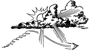 Thermals are children of the sun. They cavort
and leap about on a bright day like a schoolboy full of piss and vinegar after
long sessions of math, Latin and etiquette. They dance in the hall of the sky
to the tune called by the wind and clouds. To understand the dervish tempo and
raucous nature of their dance, we must know details of their upbringing and
surroundings. To illuminate our metaphor, we must comprehend the meaning and
effects of the lapse rate.
Thermals are children of the sun. They cavort
and leap about on a bright day like a schoolboy full of piss and vinegar after
long sessions of math, Latin and etiquette. They dance in the hall of the sky
to the tune called by the wind and clouds. To understand the dervish tempo and
raucous nature of their dance, we must know details of their upbringing and
surroundings. To illuminate our metaphor, we must comprehend the meaning and
effects of the lapse rate.
I have tried to put off discussing the
subject of lapse rate for as long as possible, for you have no doubt heard the
expression, “He who lapse last, lapse best.” But we can no longer dodge the
inevitable: To really know the heart and soul of thermals, we need to grasp
their intimate involvement with lapse rate.
Meaning Revealed
 It is not hard to understand the basics of the
lapse rate if we simply realize it is a graph of the air’s temperature at
heights from the surface upward. We can also call such a graph the air’s
temperature profile.
It is not hard to understand the basics of the
lapse rate if we simply realize it is a graph of the air’s temperature at
heights from the surface upward. We can also call such a graph the air’s
temperature profile.
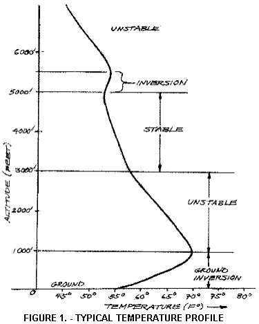
A typical morning lapse rate or
temperature profile may appear as in Figure 1. Let’s look at some details to
see what we can learn. First, we notice that near the ground the air’s
temperature is cool (55° Fahrenheit in this example). As we go higher, the
temperature actually gets warmer up to the 1,000-foot level (70° F), in this
example. Then the air cools off with altitude up to 3,000 feet. Following this,
it cools rapidly with altitude until we reach an altitude of 5,000 feet where
it actually gets warmer with altitude again. Finally, above 5,500 feet, the air
again cools off with increased altitude.
The air’s normal temperature change with
increasing altitude is to get cooler. That’s because nearly all the heat in the
air comes in at the bottom from surface heating. But moisture, movement and
pressure systems serve to alter this “normal” picture as we shall see next
month. For now, note that when the air cools off rapidly with height, the
conditions are known as unstable because they promote the rise and continuation
of thermals. In other words, the atmosphere is folding itself inside out as
thermals climb and cool air plummets.
The opposite atmospheric condition — when
the air warms with height, or doesn’t cool significantly — is known as a stable
condition. In this case, thermals are suppressed faster than tort reform talk
at a lawyer’s convention. Any wayward upward puff quickly dies out so the atmosphere
is not active vertically (even though a wind may be blowing). It lies there
limp as an overly liquored lover and is about as disappointing to a soaring
pilot.
Why do thermals rise in an unstable
environment and fall back to earth when it’s stable? For an answer free of
numbered (or numbing) details, note that the air pressure falls off with
increasing height because there is less air above pushing down. You can feel
that effect when your ears pop as you go up in an airplane, a tall elevator or
ski lift. A rising glob of air (a thermal, for example) experiences the reduced
pressure as it rises as well, and thus it expands. Its head swells so to speak.
As it swells it cools off because the same amount of heat energy is distributed
throughout a greater volume.
But the reason it began its rise in the
first place was because it was heated at the surface, expanded and became less
dense than its surroundings. Consequently, the glob will rise as long as it remains less dense than the surrounding
air, which in general means warmer. Thus, when the air’s temperature drops
quite a bit with increasing altitude, the glob always remains warmer or less
dense than its surroundings and continues to rise, even though it is cooling as
it is rising. The glob in this type of environment is what we call a thermal.
In the opposite condition — when the
surrounding air doesn’t cool off at the rate the glob is cooling with increased
height — the glob eventually reaches the same temperature and thus density as
the surrounding air and is no longer buoyant. This condition is the stable
situation.
Note 1: Lapse rates can be quite varied,
so conditions can be anything from extremely unstable to neutral to extremely
stable. You can imagine the different buoyancies or upward impetus of thermals
in these varied air conditions. The amount of available heating and wind in
combination with the lapse rate is what determines the nature of the thermals
of the day.
Note 2: For details on actual temperatures
and changes of thermals with height, see Understanding
the Sky.
Now let’s return to our figure. In view of
our previous discussion, we see that the lower layer (to 500 feet) is very stable because it gets warmer with
height. We call such a layer an inversion
because the situation is the inverse of the normal cooling with altitude.
The inversion that occurs at the ground is called (what else?) a ground inversion.
A bit higher in our figure, the air cools
off quite a bit with altitude, and is labeled unstable. Higher still its
cooling is reduced to the point that the air is stable. Then we come to another
layer that warms with altitude (at 5,000 feet) which is another inversion.
Finally,
above that the air is again unstable.
Lapse Rate Changes
 Since we know the thermal prospects change from
day to day, it doesn’t take an Airistotle
to figure out that the lapse rate itself changes. Let’s see how these changes
occur and how they affect thermals.
Since we know the thermal prospects change from
day to day, it doesn’t take an Airistotle
to figure out that the lapse rate itself changes. Let’s see how these changes
occur and how they affect thermals.
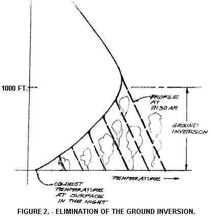
The most obvious change in the lapse rate
is caused by the sun’s great variation in heating as the 24-hour day
progresses. At night, as the earth’s heat radiates off, the air at the surface
is cooled so the ground inversion of Figure 1 is formed. The thickness of this
inversion depends on the extent of cooling (how clear the air is and whether or
not clouds block the radiation process). Also, in mountainous areas, additional
cool air will cascade down the mountain sides to increase the pooling of cool
surface air.
In the morning, this surface air begins to
heat from the bottom up. Small plumes of warmed air rise a bit and mix the warm
air upward. This process is shown in Figure 2. In our example, the lapse rate
is being changed from the bottom and appears as a dashed line at various times
in the morning. By 11:30 am, we
see that the spreading of warm air upward by convective mixing has wiped out
the ground inversion. In fact, it no longer exists once the surface temperature
has reached about 73° F (in this example). As the surface heats even more, any
warm blob rising from the surface finds itself warmer than its surroundings
well past the 1,000-foot level and continues on upward. The warmer the blob,
the higher it goes, as shown.
When the surface temperature reaches 73° F
in Figure 2, thermals rise rapidly in height. This magic number is called the trigger temperature. (Of course, the
trigger temperature varies daily and from place to place, depending on the
thickness and temperatures of the ground inversion.)
Thermal Heights
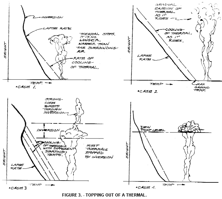 How high do the thermals go? Figure 3
illustrates the possibilities. In case 1, they rise until their cooling results
in their temperature equaling (approximately) that of the surrounding air. The
warmer the surface gets, the higher they go. You can see one reason why
thermals in the Western U.S. are much taller than their Eastern counterparts.
How high do the thermals go? Figure 3
illustrates the possibilities. In case 1, they rise until their cooling results
in their temperature equaling (approximately) that of the surrounding air. The
warmer the surface gets, the higher they go. You can see one reason why
thermals in the Western U.S. are much taller than their Eastern counterparts.
In case 2, the thermal never cools to the
point of equaling the surrounding air temperature, but gradually erodes to
nothing as it climbs higher. The erosion process is due to the mixing caused by
friction at the thermal’s edges and entrainment of outside air into the thermal
(more on this process in a later installment). The situation in this case often
occurs when there are weak thermals (those produced under a layer of high
cirrus, in hazy conditions, over water or in winter). In this case, the larger
the thermal, the higher it will climb.
In case 3, the thermals reach an inversion
layer and get the brakes put on as if they were trying to penetrate molasses.
We have also shown one situation where the thermal enters an inversion layer,
gets slowed, but bursts through the top, then continues rising. In this case it
may continue upward until it erodes away, meets another (higher) inversion or
forms a high cloud. Only the strongest thermals will burst through a thick
inversion in this manner, so the clouds and thermals above an inversion will
usually be few and far betwixt.
Finally, we have case 4, in which the
thermal reaches the dew point level and forms a cumulus cloud. The dew point is
the temperature at which the water vapor contained in the thermal condenses to
water droplets. The millions of water droplets are visible as cloud. Once cloud
forms, great reserves of heat energy are released (this energy is the latent
heat of vaporization stored up when the surface moisture evaporated) so the
thermal becomes roiled and mixes rapidly with its surroundings. This mixing
with cool ambient air soon spells the demise of the lift in that particular
area unless a continuous font of thermals is feeding the cloud.
What determines the height of the dew
point, and thus cloud base? The answer is the humidity of the air and the
actual air temperature (warm air can hold more water vapor than cool air). With
talent we can learn to predict the height of cloud base (or whether or not
clouds will form) by taking the surface dew point displayed on a chart called a
skew T or a tephigram. By running the surface relative humidity value up a
line called the constant energy line, we find the dew point where it crosses
the lapse rate. However, this technique is beyond the scope of this series.
We should note that cases 1, 2 and 3
result in blue days (no cumulus clouds forming from ground sources).
Thankfully, case 4 occurs often enough to give us frequent skies marked with soft,
white stepping stones guiding our aerial paths.
Hopefully the above concepts give you the
idea that we can predict the thermal height of the day if we know the air’s
temperature profile (now available on the Web for most of the country), the
maximum predicted surface temperature, the surface dew point and how much a
thermal cools as it rises. This latter value is 5.5° F per 1,000 feet of rise.
(You knew we’d slip numbers in eventually, didn’t you?)
Now here are a couple of wrinkles in the
process. As the day progresses, the earth’s surface tends to dry out as
thermals wick moisture upward. Consequently, cloud base rises higher (the dew
point moves up) since the thermals’ water vapor content is less. 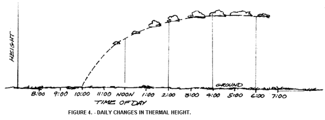 A typical daily process is shown in Figure 4. We
have already seen that thermals rise higher as the surface temperature rises,
so these combined effects produce higher rising lift until a peak at about 3:00
pm. Of course, this typical cycle
may vary if heating is delayed, or excess clouds reduce heating. Next month
we’ll see the effect such a process has on inversion layers.
A typical daily process is shown in Figure 4. We
have already seen that thermals rise higher as the surface temperature rises,
so these combined effects produce higher rising lift until a peak at about 3:00
pm. Of course, this typical cycle
may vary if heating is delayed, or excess clouds reduce heating. Next month
we’ll see the effect such a process has on inversion layers.
The final point to understand is that
thermals are like massive hot-air balloons that have great inertia. It takes a
while to get them started and they are reluctant to slow down once they are
buoying upward. As a result, they penetrate quite readily as much as 1,000 feet
above the height where they are no longer warmer than their surroundings. They
always penetrate a distance into inversions (while usually becoming broken) and
may punch through a weak one. In fact, many studies have shown that by the time
a thermal has reached two-thirds to three-fourths of its maximum climb, it is
no longer warmer than its surroundings, although it still rises by virtue of
its inertia and water vapor content which makes it a bit less dense than its
surroundings. As a result of these factors, determining the height of the lift
based on the lapse rate chart will always underestimate the actual experienced
level. It takes a practiced predictor to guess the correct values.
What You Can Use
Think
about how the lapse rate changes from night to day and realize that just
because the night is clear and cold doesn’t mean that the next day will be one
of great thermal production. What is important is the (in)stability of the air
above the ground inversion. I recall one day during the East Coast
Championships in the Sequachie Valley. Everyone thought we were going to have a
great day since the air was clear, crisp and cool. A few anemic morning thermal
currents came up to stir our juices, but the air mass was stable and we sled rode all day long. Someone could
have written a thesis on group depression that day.
Part of the fun of flying engine-free is
taking what you can find and making the most of it. However, if you are a pilot
with limited time resources (read family obligations), and you have to choose
your days, it behooves you to learn to read the lapse rate diagrams to predict
the days with good conditions. In order to do this effectively, you must
understand the principles.
Another useful point is to note that the
nature of thermals of the day is greatly determined by the nature of the
surrounding air. So, the sooner you figure out what the thermals are like
(wide, narrow, short, tall, turbulent, smooth, tilted, shifty, multi-cored,
strung out downwind, continuous, short-lived, pumping, infrequent, etc.), the
better you will be able to exploit their gift of lift. The lapse rate changes
slowly during a day’s progress, so the nature of the thermals changes slowly as
well.
Finally, when you begin your flight, it is
very wise to scope out the type of “top conditions” you encounter. If you
determine that an inversion is stopping the thermals, you can work hard to
punch through it and possibly get hundreds or thousands of feet above those
bouncing up against the ceiling. The technique for doing this will be discussed
in our final installment.